
This page uses geosites to tell the fascinating story of Suffolk's geology. You can visit them - all sites listed are publicly accessible or easily viewable. Click on the site names for more information.
Chalk
Claydon Church Lane Pit - spectacular artificial cliffs of white Chalk may be viewed from the road.

London Clay
Download GeoSuffolk's leaflet on the London Clay.
This photo below of Nacton Cliff CGS on the Orwell estuary shows London Clay, Harwich Formation.

Harkstead Cliff CGS on the Stour estuary shows excellent exposures of London Clay, Harwich Formation.
Coralline Crag
Richmond Farm SSSI - a disused pit on private land (viewed from the road) with exposures of Coralline Crag, Suffolk's unique deposit.
Orford Castle Pit CGS is a good place to view Coralline Crag. This is part of the Orford Castle National Scheduled Monument, so it has public access, but please do not disturb the geology.
Rockhall Wood SSSI on private land at Sutton shows a 150m exposure of Coralline Crag, which can be seen from the public footpath.

Part of the Coralline Crag has been cemented by calcium carbonate to form an indurated layer called the Rock-Bed - seen at the top of the exposure at Rockhall Wood SSSI above. For more information on the Rock-Bed and its use as a building stone see GeoSuffolk's leaflet, Suffolk's Coralline Crag Rock-Bed.
Red Crag
This photo of Buckanay Farm pit SSSI, Alderton (taken from the footpath along the farm track) shows current bedded Red Crag - see also Butley Forest Pit CGS on Forestry Commission open access land.

The Great Pit CGS at Newbourne Springs has a good exposure of Red Crag with public access - see our icon for this page.
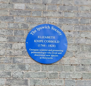
There is a blue plaque for Elizabeth Knipe Cobbold on the stable block in Holywells Park in Ipswich. She lived here and collected fossil molluscs from the Red Crag on her estate. Many of her specimens were published in James Sowerby's Mineral Conchology between 1814 and 1824. For more information see the Suffolk Naturalists' Society Transactions 2020.
Norwich Crag
Westleton Heath Pit CGS - Norwich Crag sand and gravel ('Westleton Beds') exposures on open access land in the RSPB reserve.
Dunwich Heath Cliff CGS shows Norwich Crag sand and gravel ('Westleton Beds').
Westleton Common CGS - GeoSuffolk's panel interprets the Norwich Crag gravels here.

Cromer Forest Bed
Kessingland - Pakefield SSSI - the Cromer Forest Bed is exposed in the foot of the cliffs south of Lowestoft.
Till - glacial deposits
Thorpeness Cliff CGS - the most southerly exposure of glacial till in the cliffs of East Anglia.
This photo shows Lowestoft Till in the top of the cliffs at Pakefield.

Interglacials
Stutton SSSI - interglacial deposits in the low cliffs on the north bank of the Stour estuary.
Devensian
Eastall's Pit, Barham - Devensian river terrace gravels in the Gipping valley.
Knettishall Heath CGS - this Suffolk Wildlife trust reserve shows periglacial patterned ground.
In Breckland with GeoSuffolk - visit this former frozen landscape.
Landslides
These occur along the wooded London Clay slopes of the Stour, Orwell and Deben estuaries.
This photo shows Bridge Wood CGS landslide.
.

Springs
Springs and seepages at the junction between the Red Crag sands and the London Clay are a recurring theme in the landscape.
Holywells Park CGS, Ipswich
Christchurch Park CGS, Ipswich
Rivers
Otley Gull is one of several deeply incised stream valleys in the glacial till of 'High Suffolk'.
Rattlesden River CGS is representative of rivers on the 'High Suffolk' tills, initiated following the retreat of the Anglian ice sheet. It is in the grounds of the Food Museum in Stowmarket.
Beaches and Cliffs
This photo shows Thorpe Ness CGS - one the large curved Suffolk nesses extending above high water, which occur along the coast at intervals.

Dunwich Cliff CGS - swash alligned beach with actively eroding cliffs of Norwich Crag gravels.
Find out more
For those who own or manage geosites in Suffolk, Geosuffolk's Privacy Notice may be read here.
There are 31 public CGS (County Geodiversity Sites) in Suffolk. Use the Protecting Our Geodiversity section of the GeoSuffolk Handbook, Earth Heritage Suffolk, for further information.
Suffolk has 40+ Geological SSSIs (Sites of Special Scientific Interest), administered by Natural England. To find out more about SSSIs go to the Natural England website.
The British Geological Survey publishes geological maps of Suffolk. Contact the BGS or UKGE based in Reydon, Suffolk.
Simplified Stratigraphic Column for Suffolk.